 Search


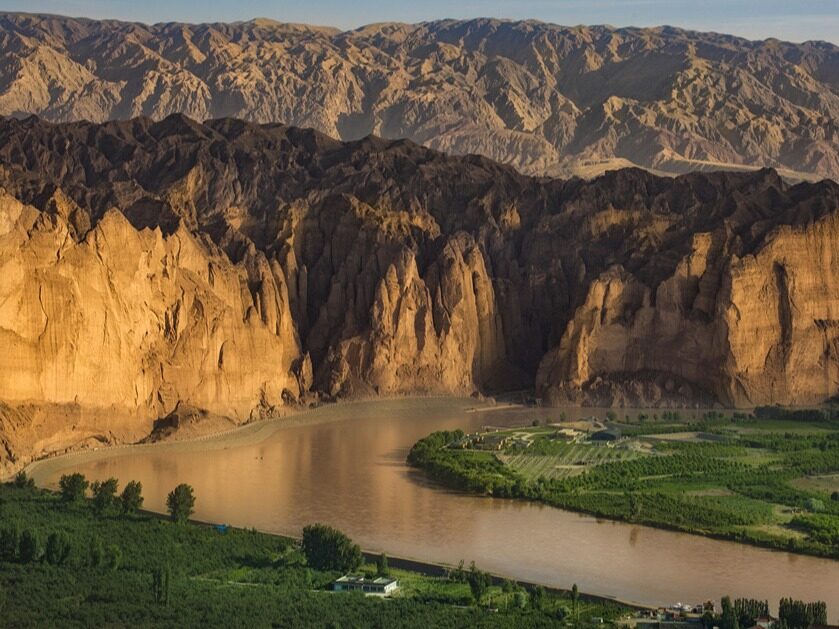
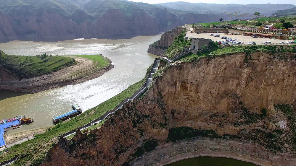
- The Yellow River exists in the section of the Hanging River, which occupies one-sixth of the entire length of the Yellow River
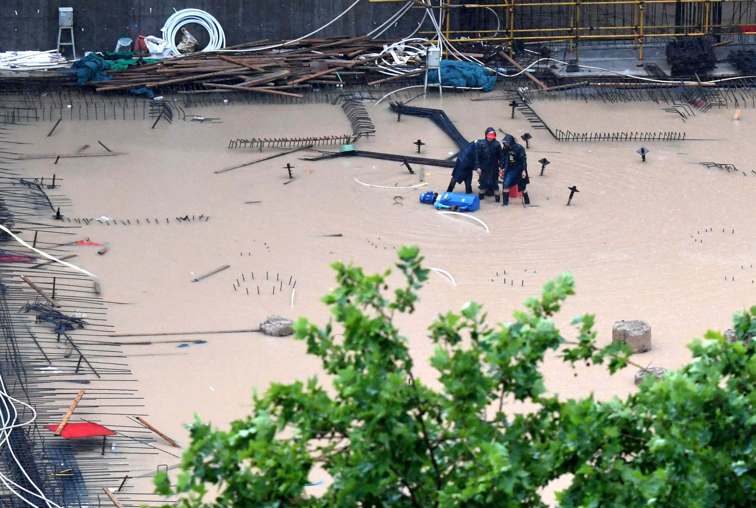
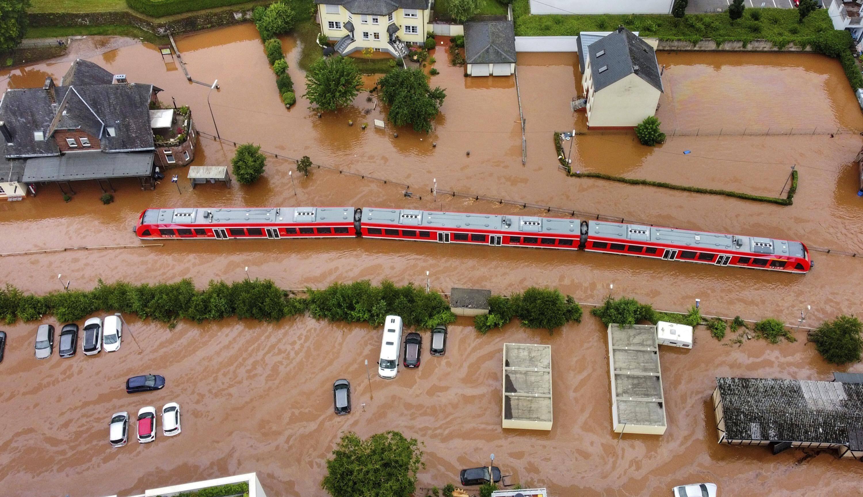
For thousands of years, the changes of the Yellow River have brought profound and heavy disasters to the North China Plain of China and to the people who have lived in the North China Plain for generations. In late July 2021, Zhengzhou, Henan experienced the most severe rainstorm in history, with a maximum hourly rainfall of more than 200 mm, which is said to be the highest hourly rainfall of all provincial capitals in the world. The disaster caused a total of 14.786 million people in 150 counties (cities, districts) in Henan Province to be affected, and 398 people died or missing due to the disaster, including 380 people in Zhengzhou City, accounting for 95.5% of Henan Province; the direct economic loss was 120.06 billion yuan, of which 409 people were in Zhengzhou City. 100 million yuan, accounting for 34.1% of Henan Province. Why does the Yellow River pass through Zhengzhou without taking a drop of water? It is only because the Yellow River becomes a hanging river on the ground when it arrives here, and Zhengzhou is the place under that hanging river.
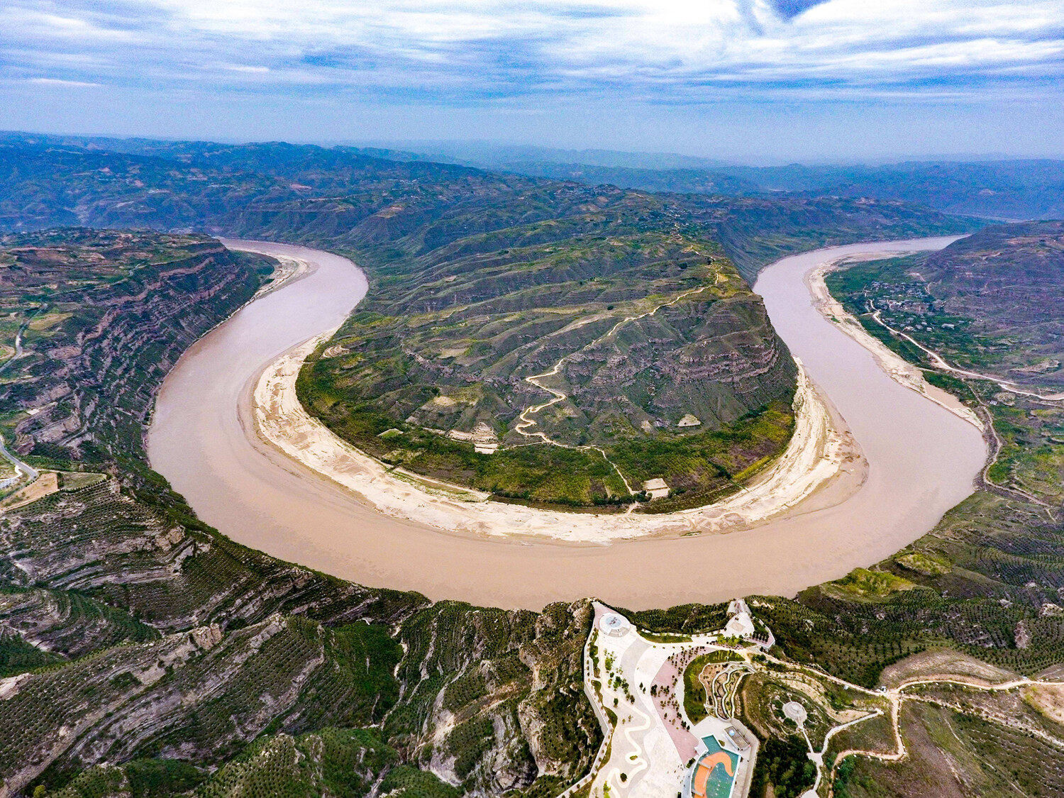
Now the lower Yellow River has become a suspended river on the ground, and hundreds of millions of tons of quicksand are buried in the Yellow River. According to water conservancy experts in Henan Province, 1 cubic meter of Yellow River water contains nearly 70 kilograms of sand, and more than 90% of the sediment in the Yellow River comes from the loess high slopes. Because of the lack of vegetation protection on the Loess Plateau, soil erosion is serious, and a large amount of sediment is washed into the Yellow River in the rainy season every year. At present, the total length of the Xuanhe River in the lower reaches of the Yellow River has exceeded 800 kilometers, accounting for one-sixth of the total length of the Yellow River, and about 400 million tons of sediment accumulates every year.
Professor Han Yuping, dean of the Yellow River Science Research Institute of North China University of Hydraulic and Electric Power, pointed out that torrential rains in the middle reaches of the Yellow River are frequent, intense and short-lived. At present, the total storage capacity of water conservancy projects in the Yellow River Basin has reached 90 billion m³, and the effective storage capacity has exceeded 45 billion m³, forming a relatively complete flood control engineering system, but the flood problem cannot be completely solved. Therefore, in the future, the development of downstream urban agglomerations and the management of floodplains must consider the possibility of encountering excessive floods in the future, make flood control plans, and establish flood forecasting and early warning systems to protect the safety of people's lives and property.
Four major causes
The sediment content in the Yellow River water is large. According to historical data, the vegetation coverage in the Loess Plateau, where the Yellow River flows, was relatively high before the Qin and Han dynasties. During the Qin and Han dynasties, due to the relative stability of the society, the population increased greatly, followed by various construction projects and reclamation of wasteland. The result is that the loose loess layer loses the protection of vegetation, and the erosion of water aggravates the soil erosion. As a result, the water of the Yellow River becomes turbid, and the Loess Plateau also becomes a fragmented and ravine landscape. In history, as many as 1.6 billion or more sediments were brought to the Yellow River, which is one of the main reasons why the lower, middle and lower reaches of the Yellow River, especially the section from Kaifeng to Jinan, have become suspended rivers on the ground.
The Yellow River has many gulf streams. The changeable flow of the Yellow River has made the Yellow River have countless river bends and loops. However, this problem is not actually the main reason why the Yellow River has become a suspended river. From the Xia-Shang period to the Eastern Zhou and Warring States period, the climate in the Yellow River Basin was relatively humid, with more precipitation than in other regions, and the forests and vegetation were not as dense as they are now. At that time, there was not only one channel in the lower reaches of the Yellow River, but it flowed recklessly on the North China Plain in the form of "radiation", forming multiple large-scale channels called "Nine Rivers". During that period, the sedimentation of the Yellow River bed was very slow, and the possibility of a breach and diversion was also very small. As a result, the traces of early human activities gradually moved towards the Yellow River Basin. This way, around the sixth year BC, the local county annals at the end of the Western Han Dynasty already had the record that "the river is higher than the people". "The river is higher than the people" means that the height of the river bed is already higher than that of ordinary dwellings.
A combination of old and new in the river. During the 3,000 years of human migration to the Yellow River Basin, the "Nine Rivers" gradually became "Rivers". The ancient Yellow River course, which originally flowed recklessly on the North China Plain, was gradually blocked by the embankments built by people, resulting in only one river of water in all the rivers. A small part was diverted, and all the rest were brought together to form the "river" in the "river" recorded in ancient Chinese history. The "Nine Rivers" no longer exist, the water and sediment conditions of the Yellow River have also undergone significant changes, and the frequency and flow of flood peaks have also been significantly reduced. In this case, the flood loses its function of laying the river bed, and the size of the river plane and cross-section decreases year by year, and the sediment contained in the river water is confined to the small and medium-sized Yellow River channel, resulting in the main channel and the tender beach. Sediment has been accumulating in other places, and finally the boundary of the Yellow River has been changed. Among them, the construction of the production embankment in the floodplain has taken a lot of effort, and a large number of construction projects have been carried out to rectify the river channel, which has stabilized the main river channel in the downstream area and created one relatively stable place for the deposition of sediment. After the river channel further reduced by the production levee spreads over, the silt thickness on the river bed gradually decreases with the distance between the beach and the channel, which directly exacerbates the channel shape with high beach lip and low-lying embankment roots.
The length of the area that the Yellow River flows through. The Yellow River starts from the Bayankala Mountains, its source, and flows through 9 provinces and autonomous regions: Qinghai Province, Sichuan Province, Gansu Province, Ningxia Hui Autonomous Region, Inner Mongolia Autonomous Region, Shaanxi Province, Shanxi Province, Henan Province and Shandong Province, and finally ends in Shandong Province. The estuary of Huanghekou Town, Kenli District, Dongying City merges into the Bohai Sea. The total length is about 5,464 kilometers, and the area of the entire Yellow River Basin is 752,443 square kilometers.
The so-called people walking on the bottom of the river, looking up to see the sailboat, is an apt description of the river hanging on the ground. Through these four questions, we can see that the Yellow River became the reason for the hanging river. For a long time, people have adopted the method of building embankments to restrain floods, resulting in an increasing height difference between the riverbed and the ground on both sides. Although there have been no breaches or diversions of the above-ground suspended river, nearly 10 billion tons of sediment have been deposited between the embankments on the lower banks of the Yellow River. More than 10 meters, in the event of a heavy rain, the river swells, and the river banks on both sides are in danger of bursting at any time.
Conservation and governance go hand in hand
According to Wang Guangqian, an academician of the Chinese Academy of Sciences, president of Qinghai University, and a water conservancy expert, the Yellow River is the river with the largest sediment load and highest sediment content in the world. The annual average natural runoff of the Yellow River is 58 billion cubic meters, the average annual sediment transport is 1.6 billion tons, and the average sediment content is 35 kilograms per cubic meter. The spatial and temporal distribution of water and sediment is not coordinated. The amount of sediment in the Yellow River is mainly due to the excessive reclamation of the land, which leads to the destruction of vegetation on the Loess Plateau, resulting in soil erosion. The ecological environment of the Loess Plateau itself is very fragile, and the erosion of rain and river water brings a large amount of sediment into the soil. The Yellow River has caused the Yellow River's riverbed to increase continuously. The management of the Yellow River water is also the top priority of the ancient dynasties and dynasties, and the Yellow River is also the biggest problem that plagued the dynasties. However, due to the underdeveloped technology, the governance of the Yellow River by various dynasties and generations has been limited.
The Yellow River Suspended River has moved to the middle and upper reaches, and it is expanding year by year. Since the river water can only be restrained by the construction of embankments, in the event of a heavy rain, the river water will swell, and the embankments on both sides of the river will be in danger of bursting at any time. For a long time, people have adopted the method of building embankments to restrain floods, resulting in an increasing height difference between the riverbed and the ground on both sides. After the formation of the above-ground suspended river, it cannot be completely eliminated, and can only be managed continuously. There are three main measures: First, strengthen the control of soil erosion in the Loess Plateau, such as planting trees, etc., because this is the material source for the formation of the above-ground suspended river. The second is to rely on various water conservancy projects along the Yellow River to strengthen sediment retention; the third is to carry out sand dredging work when the Yellow River enters the dry season and the cut-off period, which not only excavates the sediment in the river, but also can be used as building materials .
At present, the total length of the suspended river area of the Yellow River has exceeded 800 kilometers. Basically, it is in the downstream area. It is very dangerous in the flood season. The hazard of the suspended river is so great. Woolen cloth? In fact, the country has been managing the Yellow River since ancient times, but the sediment of the Yellow River is not so easy to clean up. First of all, the depth of the Yellow River is generally 2.5 meters, and the width can sometimes reach 500 meters. The cost of removing the sediment through large-scale equipment, It is often greater than the utilization cost of sediment. The permeable silt of the Yellow River is not suitable for the construction industry at all, and its usable value is not large.
Now that technology is so advanced, is there a good way to manage the Yellow River? Some people think that since the sediment deposited at the bottom of the riverbed is the source, it would be better to dig out the sediment and lower the riverbed. This idea is too naive. Every year, more than 1.6 billion tons of sediment will be transported to the lower reaches of the Yellow River. The manpower, material resources and financial resources required to excavate the sediment are immeasurable. Therefore, the current national focus on the governance of the Yellow River, It is not used to clean up the sediment at the bottom of the river, but to strengthen the Yellow River dams, build the Sanmenxia Water Control Project, the Qingtongxia Water Control Project and the Longyangxia Hydropower Station. . In addition, the government calls on people on both sides of the Yellow River to actively return farmland to forests and plant drought-tolerant and heat-resistant plants. The roots of these plants can be deeply rooted in the soil of the loess to prevent the loess from flowing in large areas due to sandstorms. The project of "The Foolish Old Man Moves the Mountain" requires the continuous efforts of generations. Maybe in a hundred years, we will be able to see the Yellow River that is clearer than it is now.
There are two reservoirs in the Sanmenxia area on the upper reaches of the Yellow River, which are specially used to adjust water and sediment. Before the rainy season, these two reservoirs will open the gates and release water to wash away the sediment in the river, preventing the sediment from accumulating and forming a decisive problem. embankment. The second is environmental governance. Now, after decades of returning farmland to forests and grasslands on the Loess Plateau, the vegetation is much better than before, and the amount of sediment in the Yellow River is much less than before. In fact, to solve the problem of sediment in the Yellow River, we still need to find a solution from the source. Only by improving the ecological environment and reducing soil erosion can we cure the symptoms.
In short, the sediment control of the Yellow River should start from the source and the vegetation protection of the Loess Plateau. Today's management of the Yellow River has been very effective, and the water of the Yellow River has become much clearer. The governance of the Yellow River is by no means something that can be accomplished overnight. It requires the hard work of the sons and daughters of the Chinese nation from generation to generation. No matter how long it takes, I believe that the Yellow River Basin will one day become as clear as the river at its source, the banks of the Yellow River are full of fish and rice, and the people on both sides of the river live and work in peace and contentment. I believe that day will surely come. Editor/He Yuting
Comment


 Praise
 Collect
 Comment

 Share
Share


Write something~