 Search


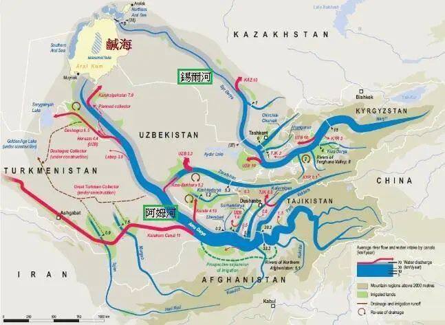
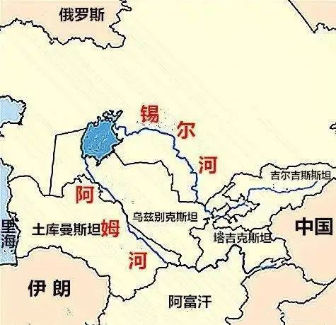
- The Syr Darya, known as Yaojishui in ancient China, has a total length of 2,212 kilometers
- The Amu Darya River, known as the Gui River in the Han Dynasty in China, and the Wuhu River in the Sui and Tang Dynasties
The Syr Darya and the Amu Darya are the largest inland rivers in central Asia, and the area between the two rivers is called "in the middle of the river" or "between the rivers". The Syr Darya and the Amu Darya, the cradle of Central Asian civilization, originate from the Pamirs.
Amu Darya
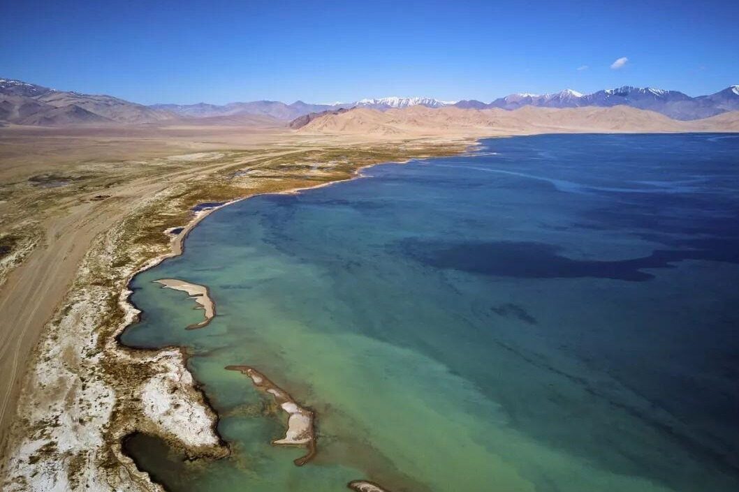
Amu Darya, ancient Chinese called Guishui (Han Dynasty), Wuhu River (Sui and Tang Dynasties). It comes from the Sogdian name for the river god Wuhu wxwsw. "Da Tang Western Regions" is recorded as "binding the water". The source comes from the 4,900-meter mountain glaciers in the southeastern part of the Pamirs and the Hindu Kush Mountains. The west flow merges with the Pamir River originating from the Pamirs, called the Pyandzh River, and then zigzags westward to join the Wach. The Shi River, later called the Amu Darya River, flows into the Aral Sea to the northwest. It flows through four countries: Tajikistan, Afghanistan, Uzbekistan and Turkmenistan.
The Amu Darya is 1,415 kilometers long; from the source, it is 2,540 kilometers long, 960 kilometers wide from north to south, 1,400 kilometers long from east to west, and covers an area of 465,000 square kilometers. Relying on the supply of alpine glaciers and melting snow, there are two flood seasons in spring and summer every year. The Amu Darya is also a cultural divide: in the 3rd century, it was Heda and Iran, and later it was Turkic and Iran. According to records, the Amu Darya once entered the Caspian Sea in history.
Syr Darya
The Syr Darya, known as Yaojishui in ancient China, originates from the Tianshan Mountains, flows through the Turan Lowland (Fergana Basin), confluences with the Naren River Kara River in the east, and flows through the three countries of Uzbekistan, Tajikistan and Kazakhstan. Finally into the Aral Sea. The total length is 2212 kilometers. The dividing line between agriculture and animal husbandry in Central Asia lies in the Syr River Basin.
Central Asia and West Asia are the intersection of three continents and five seas. They are located between the three continents of Asia, Europe and Africa, connecting the Atlantic Ocean and the Indian Ocean. The five seas refer to the Caspian Sea, the Black Sea, the Red Sea, the Arabian Sea, and the Mediterranean Sea.
Scholars who know Chinese history below the Qin and Han Dynasties will know that the Hejian Fertile Plain with two rivers to the place where the five seas and three continents meet, has been the backyard of Chinese history since the Han Dynasty.
In recent years, the historians have been misled by the West, and there is a strong theory of nomadic culture, which believes that the continuous invasion of nomads from the north of the Great Wall has affected the trend of Chinese civilization and history. This is actually a superficial argument.
It was not the nomads from the grasslands that really influenced and changed the history of China, but the merchants and caravans of Central Asia and West Asia. Nomads are often their tools. Editor/He Yuting
Comment


 Praise
 Collect
 Comment

 Share
Share


Write something~