- Studying the Nile Estuary and the evolution of the two river basins from the old map

The historical historical writings in Western historical works are speculated and traced by the descendants according to the legends. Therefore, the historical events mentioned in Western historical works are often pushed forward a lot. How many? It’s been thousands of years, even thousands of years. Here we only look at the evidence of the forged history related to ancient Egyptology based on the archives of ancient Western maps.
The following ancient Egyptian maps are arranged in the order of the drawing years.
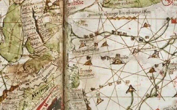
A chart drawn on a single-page sheepskin board in the 13th century. This is the existing sea and land map related to the Mediterranean Sea in Egypt, which was drawn around 1276. (The white is the land in the picture, the Mediterranean is the green, and the green line is the Nile.)
From the 13th century map of ancient Portland, the Nile estuary delta did not exist at the time, and the Nile estuary was still a bay.
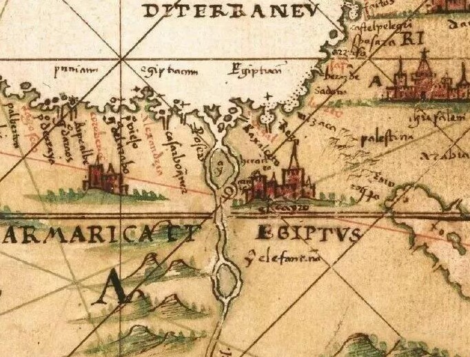
A map of Egypt and the Mediterranean made by the Spanish in the 16th century. This picture was made during the reign of Philip II. Produced for Alonso de Santa Cruz, a paper map that appeared earlier in Europe.
As can be seen from the figure, the Nile Delta was not formed at the time, only some sandbars and islands. It is worth paying special attention to the fact that the capital of Egypt is now Cairo, Cairo, but on the map at this time, it is marked Cayzo, and Cay is the meaning of islands and reefs, indicating the geographical features of Cairo in the early days of the city. Cairo is built on island reefs. Formed on land. The history of this city will not be very long.
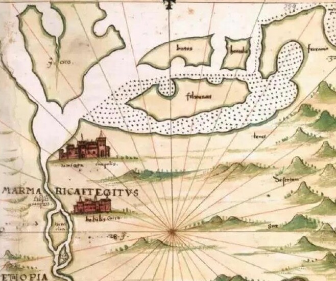
This is a partial enlargement of the Nile Bay, marking the names of the various alluvial islands such as yoro in the bay. A lot of small spots to draw the shallow waters. Explain that the map maker is extremely familiar with the area and has done a lot of detailed mapping work.
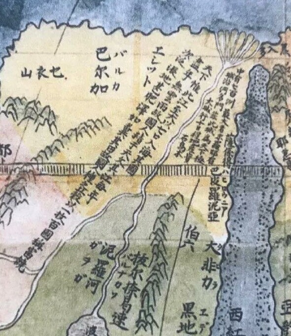
This is the part of the Nile River in the "Kun Yu Wan Quan Quan", written by the European Catholic scholar Ricci in the 17th century. The authors of this picture are Matteo Ricci and Li Zhizao. The descriptions of Egypt and the Nile in this picture are as follows:
"The world is only the river (Nile River) to the big, with seven mouths into the sea, the country is full of clouds and rains, so the people are good at astronomy. The river is once a year, the land is very fat, such as the feces, the national race Valley, with a herd, a hundred countries called rich. There are seven hundred continents, the largest is the end of Luoye. There is a city along the river, the name 'Men Fei this' city, for the great city of the world. Line ten schedule. Real estate gem ebony."
In the Ming Dynasty, the Chinese called the Egypt and the Arab region a Micha, but the "Kun Yu Tu" did not see this place name - so the Mi Xier was not specifically referring to the land of Egypt. Cairo, the pyramids, the Sphinx and the description of Alexander City are also not seen in the picture. Only a city name "Men Fei this" - should be Memphis.
Memphis is an ancient Egyptian city, now located in the border between Egypt and the United States, Mitt Lacina, then according to Kun Yutu, it should also be a sandbank in the Nile. The famous Khufu Pyramid and the Sphinx are in Memphis, but there is no word in this picture.
In the Ming Dynasty, the Nile River had seven mouths into the river (now only three). The entire Nile River estuary has been deposited for nearly four hundred years. The city of Alexandria near the mouth of the Nile River should also be the sea or the seashore swamp.
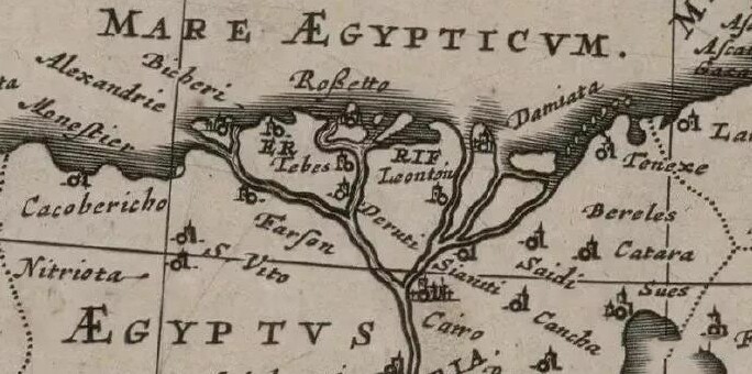
This is the part of the Nile estuary in the Osman Turkey map drawn by Blau Willem Janszoon Blaeu (AD 1571‒1638) in Amsterdam in 1635. The drawing person is a student of the famous Danish astronomer Tycho Brahe.
From this picture we can see that the Nile Delta is still forming. The sandbars of a hundred years ago are turning into land, but there are many small islands in the mouth of the five rivers that enter the sea. In the part of the Alexandria region, there is a river island formed by alluvial. Later, the French claimed to find the place where the Rosetta stone was, and it was still the bay. There are only a few new alluvial islands in the bay. Damietta is also a bay with islands.
In 1740, an important French cartographer, Gilles Robert de Vogondi (1688−1766), mapped the Nile Delta as above. The picture is called: Ottoman Empire in Asia, Persia, Uzbekistan, Arabia and Egypt.
It is worth noting that the location of the famous Alexandria City in this picture is just a small sea otter and is surrounded by lakes and swamps. The Rosetta, which found the stone monument, became a peninsula from the sea, but the left and right sides are still bays. Damieta has formed into a peninsula. It was originally an island of Berros that still has direct access to the sea.
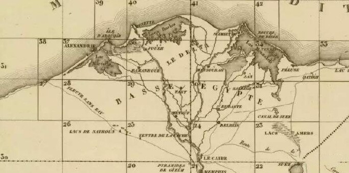
This image is from the map of the Nile Delta in Napoleon's Egyptian Remarks, atlas of Egypt and Parts of Bordering Lands (Plates), drawn from 1798 to 1801. .
In 1802, Napoleon authorized the publication of the research of the Egyptian Council for Science and the Arts in a commemorative multi-volume work, including plates, maps, academic papers and detailed indexing. The original English translation was published in 1809.
It is clear from the above picture that there are large lakes between the Alexandria and Rosette regions, separated only by narrow lakes. In the Damietta area of Figure 4, there is still a bay with many small islands.
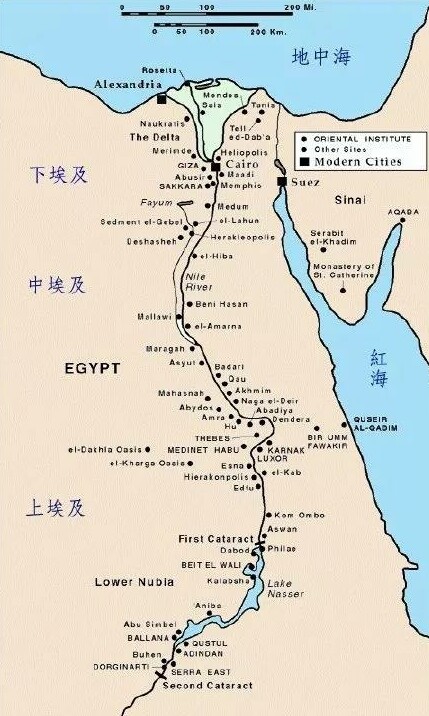
This is a modern map of Egypt. This is the current landscape, and the scattered islands of the Nile estuary have been linked to land. Alexandria, Rosetta, Cairo are all on the oasis land.
From the above, it is not difficult to see the changes in the landscape of the Nile estuary in the past few hundred years: from the 14th to the 15th century, there was no alluvial plain in the estuary, there were islands in the strait, and then there were sandbars and islands, gradually changing. Big, then to the delta wetlands, to the formation of plains, lakes, and finally to the coast of the modern landscape.
More than seven hundred years. In the last 200 years - in this place that was originally a sea and a coastal wetland, it was possible to discover a large number of ancient monuments, antiquities, papyrus and ancient stone monuments that were more ancient 8,000 years ago. Is it funny?
Since there was no historical habit and system in the West, there was no credible historical record in Western history. Westerners basically had no credible records and concepts about history. Editor / Zhao Jing
Comment
 Praise
 Collect
 Comment
 Search





Write something~